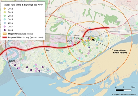
Water voles have been discovered thriving across the Gwent Levels after bouncing back from extinction on the internationally-important wetlands of south Wales. Six years ago, Gwent Wildlife Trust reintroduced the endangered species to Magor Marsh nature reserve on the edge of the Levels. New mapping shows that they have bred successfully and spread up to 10 kilometres.
The water vole is the UK’s most rapidly declining mammal and has been lost from 94% of places where they were once prevalent; earlier this year a report* revealed an ever-worsening situation. Thus, the new map created by Gwent Wildlife Trust is very heartening and shows water voles are reclaiming their historic range. (See Editor's notes for map.)
Unfortunately, the news comes at a time when the Welsh government is due to announce a decision which will decide the fate of the Gwent Levels. A new 14-mile-long six-lane motorway is proposed; it will cut across six protected wildlife havens and destroy or damage a historic landscape which is Wales’ equivalent to the Amazon rainforest. Rare wildlife such as water voles, otters and cranes will be badly affected.
We need everyone who cares about nature to voice their concern about these destructive plans
Ian Rappel, chief executive of Gwent Wildlife Trust says:
“The fantastic success of the water vole reintroduction project is a wonderful testament to all the great efforts of volunteers and staff working to enhance the Gwent Levels for wildlife. This beautiful landscape is a nature-lover’s paradise and people really enjoy its peace and tranquillity. But the success is bitter-sweet. If the new road gets the go-ahead billions will be spent destroying a very special place for the sake of saving ten minutes of commuting time.”
Ian Rappel continues: “Gwent Wildlife Trust fought the new road proposals during the Public Inquiry – but now we need everyone who cares about nature to voice their concern about these destructive plans. We believe that Welsh Government should scrap the billion-pound-plus road and invest, instead, in a modern public transport system for the people of Wales.”
Iolo Williams, TV presenter says:
“This road is going to destroy Sites of Special Scientific Interest – these are the jewels in the Welsh crown. This road is going to destroy habitat for otters, for water voles and for cranes which have nested on the Levels for the first time in 400 years. Let’s make sure the Welsh government wakes up to its commitment to future generations. There are better and cheaper alternatives to this idiotic development.”
Stephanie Hilborne OBE, chief executive of The Wildlife Trusts says:
“When future generations realise the extent of the damage this generation has wreaked on our finite, beautiful, natural world they will ask "why?" Why, for the sake of a few minutes knocked off journey times, did we destroy the unique and irreplaceable Gwent Levels. Why did we think it was OK to wipe out its woods, its precious waterways, its water voles, our Forest School campfire? Together, these make a wetland of international importance. Wherever you live in the UK please help stand up for wildlife and put a stop to the M4 "black route." We do not have the right to destroy this treasure or deprive future generations of its joy.”


