Somerset Wildlife Trust have been working towards nature’s recovery in the iconic Mendip Hills of Somerset for decades. It was the first Trust Living Landscape in Somerset. Today the Mendip Hills sit at the heart of our new Wilder Somerset 2030 strategy and our goal to ensure that nature is improving across the county, supported by restored natural processes, and connected and protected through a Nature Recovery Network, with at least 30% of land and sea managed positively for nature.
Encompassing more than 30,000 hectares, the Mendip Hills covers the distinctive range of predominantly limestone hills in the north of the county stretching between Frome and Western-Super-Mare. It is extremely biodiverse, packed with rare flora and fauna, and this is reflected in numerous designations over a relatively small area. Within the Landscape there are 47 Sites of Special Scientific Interest (SSSIs) totalling 2,214 hectares: 4 Special Areas of Conservation (North Somerset and Mendip Bats, Mells Valley, Mendip Woodlands, and Mendip Limestone Grasslands SACs) and 2 National Nature Reserves. Local Wildlife Sites cover 2,341 hectares, while the Trust’s own nature reserve holding extends to 860 hectares. That is over 50% of the Trust’s County wide landholding. The central and western parts of Mendip are also designated as an Area of Outstanding Natural Beauty.
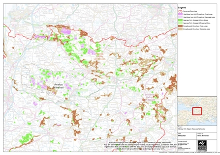
The driver for our work in the Mendip Hills has always been to restore and connect habitats at a landscape scale. We have taken a varied approach to this, with extensive partnership and engagement project work. This includes over 8 years of work funded through “section 106 agreements” (developer payments to local authorities) to support our Mendip Wildlife Links Project, carrying out land management advice visits, practical restoration with landowners and communities, and habitat and species monitoring. It’s also through working with partners on the Mendips hills that we received resource to first develop our widely used Ecological Network Modelling. This connectivity modelling is now used by partners including the council and district authorities to support decisions on planning and development. It’s also a vital layer for the developing Local Nature Recovery Strategy for the county.
Another big success came through our work on the ‘Save our Magnificent Meadows’ programme, supported by the Heritage Fund. We also co-ordinate a very successful Facilitation Fund on the Mendips and have recently been given approval for a further extension of this work.

Matt Sweeting
Partnership working is key to all we do. We strive to have a good working relationship with a wide and diverse range of partners including Non-Governmental Organisations, Areas of Outstanding Natural Beauty, landowners, private business and industry and other stakeholders. But it’s always been at a community level we’ve felt we’ve had the biggest impact. We work hard at a parish scale with local communities, engaging them with the nature on their doorstep. We have explored innovative approaches that help local people in the management of their grassland, be it a churchyard, village green, school playing field or road verge. We help people, young and old, to understand how fragile and scarce meadows are nationally, and that every small action helps to reverse the decline of these iconic habitats and aids in nature’s recovery.


